
Alba Fucens
The Roman town of Alba Fucens lies in a small valley surrounded by three hills, in an area once inhabited by the Equi, in the territory to the north-west of the ancient Lake Fucino.
History
The founding of the city forms part of Rome’s conquest of central Italy: following the defeat of the Equi, Alba Fucens (303 BC) andCarsioli (298 BC) were established to control a strategically crucial geographical area within the balance of power across a vast territory stretching along the Via Tiburtina Valeria. The fact that Alba played a key role in the military control of central Italy is confirmed by the Roman Senate’s decision to send 6,000 colonists to Alba, as recorded by Titus Livius (IX, 43,25): “Soram atque Albam coloniae deductae. ‘Six thousand colonists were assigned to Alba’.” Each was allocated a plot of land resulting from the division and organisation of the surrounding plains (centuriation), suitable for cultivation and tempered by the presence of the nearby Lake Fucino (drained in the nineteenth century).
The presence of the colonists and Rome’s esteem for this loyal city would forge an extremely strong bond between them, leading Alba Fucens to a relationship of absolute loyalty towards Rome. Indeed, as early as the beginning of the 3rd century BC, a formidable coalition (the Etruscans, Umbrians, Samnites and Gauls) was advancing on Rome; the people of Alba and neighbouring populations allied themselves with the Roman cause, thereby contributing to the victory at Sentinum (295 BC). During the Punic Wars, Hannibal advanced with his armies into the heart of central Italy and led a march towards Rome whilst the consular armies were far away. With Rome in danger, it had no choice but to seek help from neighbouring colonies. It was precisely during this episode that Alba’s loyalty was once again demonstrated, as it sent 2,000 men to halt Hannibal’s advance, forcing him to retreat southwards (211 BC). At the end of the Second Punic War, Syphax, King of the Numidians, was captured and sent into exile in Alba (203 BC). The same fate befell Perseus of Macedonia (168 BC) and Bituitus, King of the Averni. These episodes confirm that the colony was used at that time as a place of imprisonment for dethroned kings. During the Social Wars, Alba remained loyal to Rome, withstanding numerous attacks by the rebellious allies.
At the end of the Social Wars (91–89 BC), pursuant to the ‘Lex Julia Municipalis de Civitate danda’, the city, like the rest of Italy, was granted municipal status (municipium) and its inhabitants became Roman citizens in every respect. In the conflicts between Marius and Sulla (88/82 BC), Alba sided with Marius, whilst in the civil war between Pompey and Caesar (49/45 BC), Pompey’s troops stationed in the colony deliberately defected to Caesar’s side. During the Imperial period, Alba enjoyed a period of great economic prosperity. During this time, public and private monuments were renovated and embellished, whilst new structures were erected. This prosperity was also due to the economic boost brought about by the reclamation of Lake Fucino. The colony’s crisis and decline began in the 3rd century AD and became more pronounced in the 6th century following a series of earthquakes and frequent barbarian invasions, which led to the gradual abandonment of the city. Following the rise of feudal fortified settlements, by the 9th century the settlement had become concentrated on the acropolis, where the medieval village developed around the castle.
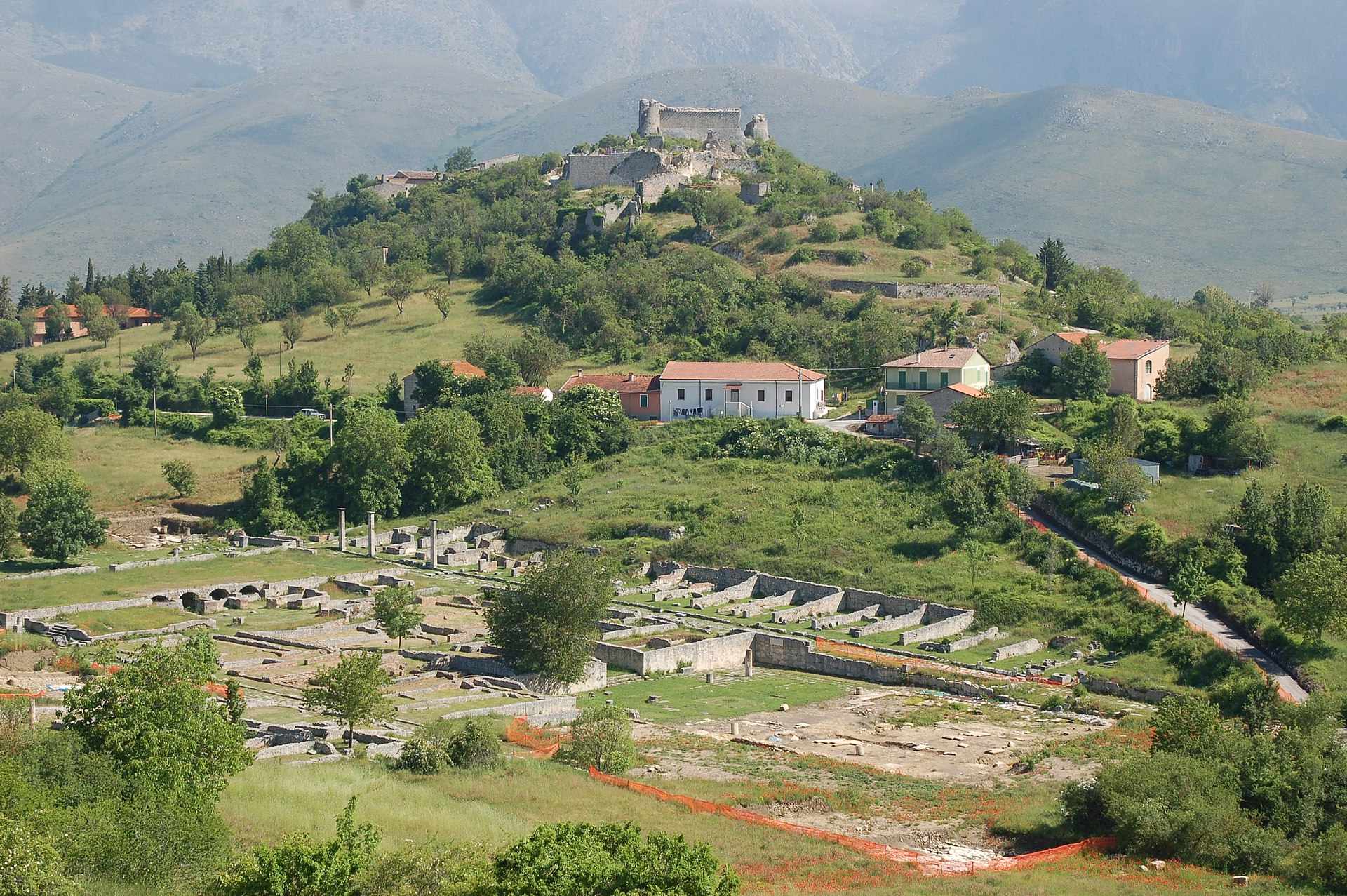
The decline of Alba as a Latin colony coincided with the decline of the Roman Empire. Among the various causes were, of course, the barbarian invasions, the collapse of the Roman administration and the provincialisation of the army, but also a lack of maintenance – leading to the re-flooding of the land reclaimed from the Fucino by Claudius – as well as the impossibility of rebuilding the buildings that had collapsed as a result of earthquakes. Thus began the period when the town’s inhabitants moved to higher, more defensible locations, perhaps further removed from the main road network, which had once been the key to Rome’s greatness but now facilitated the barbarians’ access to major strategic centres such as Alba. This period, together with the population decline of the 6th century AD, led to the abandonment of the central area of Alba, which was completed in the 11th century with the arrival of the Saracens, and the establishment of the medieval village on the main hill of Colle di S. Nicola, where the castle was built. With the arrival of the Lombards, this area was annexed to the Gastaldato of Spoleto (the coats of arms are still visible in a palace in Tagliacozzo). It was under Ludovico II that it became a county, ruled by the Counts of Marsi, beginning with Berardo I, known as ‘Il Franciscus’. In 1173, Rugerio became Count of Albe. Subsequently, the village was destroyed by Charles of Anjou during the events that followed the battle against Corradino of Swabia, which took place on the Palentini plains, that is, on the south-western slopes of the hill.
Following this event, Alba effectively began to lose its importance as the centre of the Marsica region, and its territories were contested between the great Colonna and Orsini families. Indeed, from the Countess of Gravina, Giovanna Durazzo, who held the county (1372), it passed to the Orsini, who had many of the damaged buildings rebuilt. Subsequently, the county was handed over by Queen Giovanna II to Pope Martin V’s brother, Lorenzo Colonna (1428). Eight years later, the territories passed to Giacomo Caldora, only to return once more to the Colonna family; however, they were replaced again by the Orsini, with Giovanni Antonio taking over in 1441. During this period, the Orsini shifted the centres of interest in the Marsica region from Alba to Tagliacozzo and Celano, enriching the latter two both economically and culturally, whilst increasingly neglecting Alba, which, stifled by these two new centres, would never take part in the revival that affected various centres during the Renaissance. With the establishment of the Bourbon Kingdom, the overland trade routes for wool shifted, impoverishing not only Albe, but the entire central region, which remained excluded from this trade, partly due to the rise of brigandage, a phenomenon that persisted until the early decades of the 20th century. The end of the medieval village was brought about by the 1915 earthquake, which took the inhabitants by surprise on the morning of 13 January, claiming many lives and reducing the village to a heap of rubble. Recently, a small part of it has been restored.
Following the disaster of 1915, wooden huts were erected in the S. Maria threshing floor area (at the foot of the hill of S. Pietro) to house the earthquake victims. A few years later, the civil engineering department, with state funding, built permanent, earthquake-resistant dwellings within the Roman city walls, forming a sort of horseshoe shape around the ‘Piano di Civita’. As the town was still lacking public buildings, plans were drawn up for a new parish church. The first, dating from 1921 and drawn up by Engineer Bultrini, envisaged a building with three naves instead of one, and did not incorporate elements salvaged from the earthquake rubble – including the rose window – and was therefore rejected. Subsequently, in 1935, a new design was presented, drawn up by surveyor Colabianchi and engineer Amorosi, who, following the guidelines of the Superintendency and the new anti-seismic building regulations, constructed the church as a single-nave structure, with a façade similar to that of the destroyed (in the L’Aquila Romanesque style), incorporating the rose window and the original portal from the old church of St Nicholas. During the Second World War,Alba proved, as indeed throughout its history, to be a strategic location. In 1943, Field Marshal Kesserling established his headquarters for the Gustav Line in Massa D’Albe (the present-day municipality of which Alba is a hamlet). In Alba Fucens, on the ‘northern terrace’ (presumably the campus of the ancient city), anti-aircraft defences were established. After the war, following the Allied victory, the law imposed by Mussolini preventing emigration was repealed, and the town began to lose its population. In 1949, a Belgian archaeological mission, led by the University of Leuven, began an excavation campaign that continued for around thirty years. The civita, where the public buildings of the Roman city were concentrated, and the amphitheatre were brought to light. The city is still the subject of research by the Superintendence for Archaeological Heritage of Abruzzo and a number of Italian and foreign universities.
The town
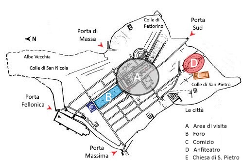
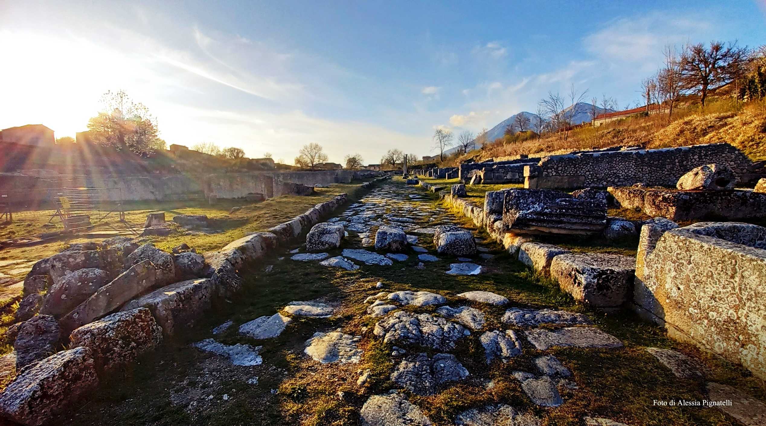
Alba Fucens is surrounded by imposing polygonal stone walls stretching 3 km in circumference, with four gates along its length. Even today, one enters the town via the Porta di Massa, to the east. The Via Valeria entered the town through the Porta Massima, to the west, and shortly afterwards led into the forum. The town centre is divided by perpendicular axes that form blocks within which the public buildings are situated. Via del Miliario, running north-south, follows the route of the Via Tiburtina Valeria through the city; the cross-street Via dell’Elefante connects it to the parallel Via dei Pilastri. The tour takes place in the central area of the city, winding through the streets and past the main buildings lining them, set within a landscape of exceptional beauty, dominated by the summit of Monte Velino.
The buildings and streets
Via dell’Elefante, so named following the discovery of two plinths bearing depictions of these animals, leads to the entrance tothe Basilica (1), which occupies the space between Via del Miliario and Via dei Pilastri. Justice was administered in this spacious building and, in the event of unfavourable weather conditions, the activities of the forum were moved there. The raised podium at the rear was perhaps where the magistrates sat, and in front of it, two rows of columns – some of whose bases are still visible – divided the interior into three longitudinal naves. Light entered through the taller central nave. The three entrances along the long side break up the solid wall built of irregular stone.
ThePortico (2)in front of the basilica has been identified asthe diribitorium, that is, the place where voting took place. Its perimeter is marked by the column bases along Via dell’Elefante and by the paving slabs covering the area. Further north, the elongated area ofthe Forum (B) can be recognised, the nerve centre of the city’s administrative and political life. At the far end of the forum, investigations have revealed theComitium (C), a meeting place for civic assemblies, which is no longer visible today.
Via dei Pilastri, running parallel to Via del Miliario, takes its name from the pillars that once supported a portico. Along this street, amongst the row of similar buildings facing onto it, one can make out shops orTabernae(3). One of the first is thethermopolium, a small refreshment outlet, as indicated by the counter at the front for displaying and selling food, and the stone basin with lead piping for the water supply, on the right. Rows oftabernaealso line Via del Miliario. TheMacellum (4) extendsto the south of the basilica and was the place where essential goods such as grain and meat were purchased. It could be reached from both side streets. In the 2nd century AD, the market was redesigned, and its original square layout was replaced by the current one, with brick shops arranged in a radial pattern around a central square. The four large arches at the far end were closed off at that time.
After themacellum, you enter theBaths (5), intended for personal care. The small brick columns (suspensurae) supporting the floor, visible in a room on Via dei Pilastri, allowed hot air to circulate beneath it. The nearby basin was used as a swimming pool. Within the thermal baths are the public baths, characterised by marble slabs with a central hole set into the wall and drained by a sewer system below. TheTheatre (6) stands to the left of Via dei Pilastri, where only a few traces can be seen in the concave depression carved into the rock, believed to be the remains of the cavea.
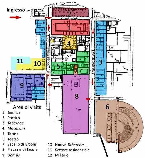
TheSanctuary of Herculesconsists of a small chamber dedicated to the worship of the god(7)and a large square in front of it(8), where numerous excavation campaigns have been carried out in recent years. The small shrine housed a monumental statue of Hercules seated at a banquet, now preserved at the National Archaeological Museum in Chieti. The presence of the god in a square used for the trade in animals ensured that business dealings were conducted with integrity. The god Hercules was the protector of salt and herds and was therefore highly revered in a society that derived most of its livelihood from a rural and pastoral way of life. Crossing thePiazza of the Sanctuary of Hercules (8), one arrives atVia del Miliario, from which, by climbing a flight of steps, one reaches a large building, identified asa Domus(9), but perhaps also used for other purposes (collegium). The original structure dates back to the 2nd century BC, whilst what we see today is a reconstruction from the 1st century AD. In the atrium, a depression in the floor (impluvium) can be seen, designed to collect rainwater falling through the opening in the roof. Opening onto the porticoed garden with brick columns were bedrooms (cubicula) and dining rooms (triclinia), with mosaic floors.
In the next block, recent excavations have brought to lightnewtabernae(10) and aresidential area (11). The final significant monument is theMiliario (12), a broken column that gives the road its name; it marks the distance of 68 miles from Rome and commemorates the restoration work commissioned by Emperor Magnentius in 352 AD.
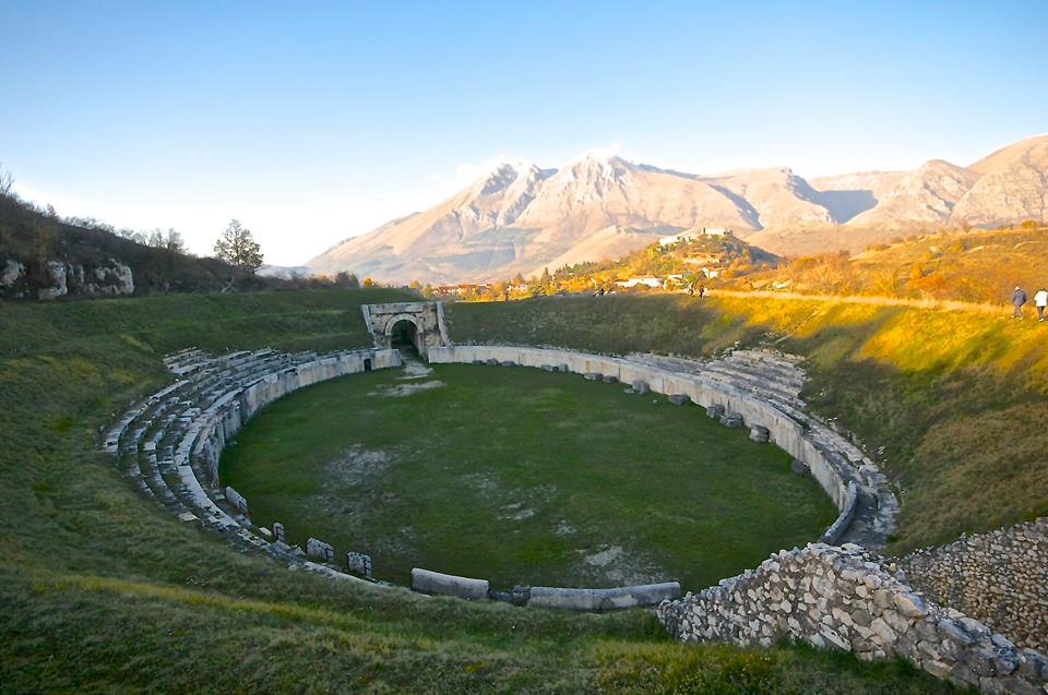
Outside the central area, accessible via a path branching off from the road leading to the hill of San Pietro, standsthe Amphitheatre (D). Oval in shape and measuring 96 by 79 metres, it was built in the first half of the 1st century AD thanks to the will of Quintus Nevius Sutorius Macron, commemorated in the inscription on the entrance arch. In the lower part of the cavea, the entrances for the gladiators and wild beasts remain.
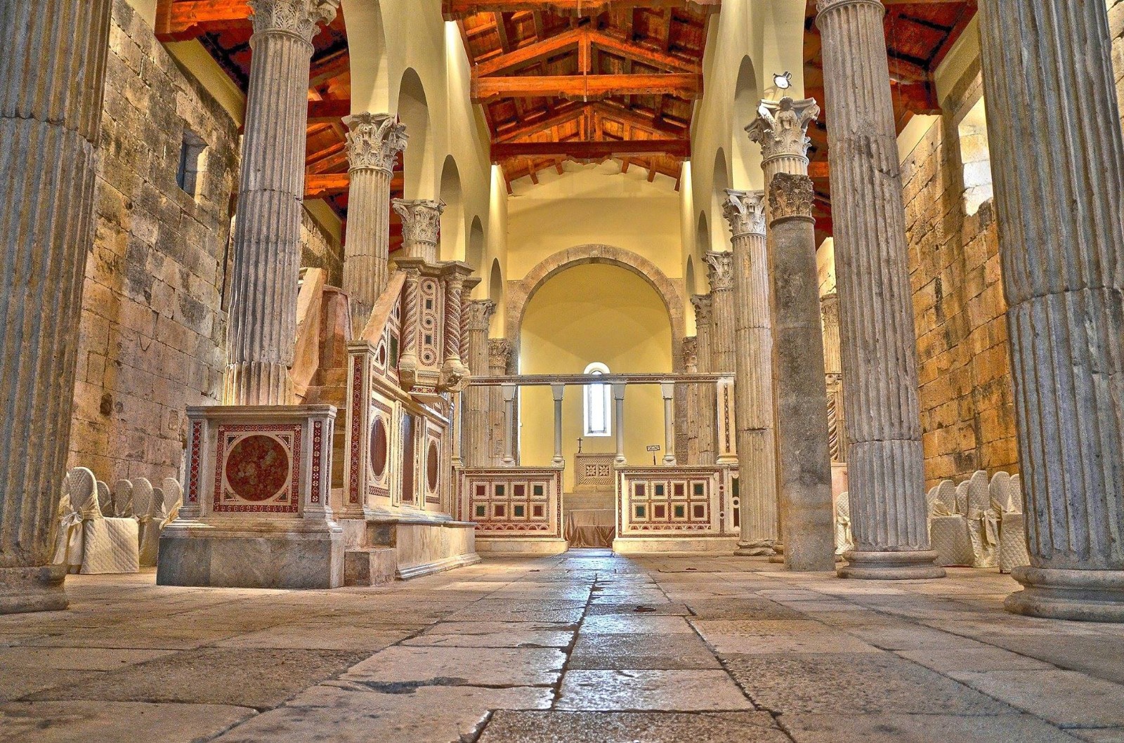
TheChurch of San Pietro (E) standson the hill of the same name. It is built on the site of the Temple of Apollo, of which some original columns remain, incorporated into the masonry. The fluted columns with Corinthian capitals come from another building in the town and divide the church into three naves. Inside, there is an ambo and a 13th-century AD Cosmatesque-style iconostasis. The church suffered severe damage during the earthquake of 13 January 1915 and was subsequently rebuilt.
Adjacent to the church stands the Benedictine Monastery, the date of construction of which is uncertain (it is thought to be after the 10th century), with a layout typical of monasteries of the period, featuring a central cloister and an inner courtyard, onto which all the rooms comprising the rest of the structure open: dormitories, storerooms, the refectory, the kitchen, warehouses and prayer halls. Beneath the cloister, it is worth noting the presence of a rainwater collection tank, from which water was drawn via a central well, both of which are still in working order. The monastery is not open to visitors as restoration work is currently underway.
Church of St Peter
The Church of St Peter in Albe stands on the hill of San Pietro, one of the three hills surrounding Alba Fucens. The earliest evidence of this Christian place of worship dates back to the mid-6th century AD, when the Roman temple of Apollo, dating from the 3rd century BC, was converted into a church. The temple, of which three sides remain, originally had a portico with four columns. Only faint traces of the early Christian phase remain, including fragments of reliefs on display at the Marsica Museum of Sacred Art in Celano (AQ). In the 12th century, the rear wall was partially demolished to create the apse and the crypt beneath it; the interior was divided into three naves; and the walls along the long sides were extended beyond the colonnade of the Roman temple, incorporating the side columns of the ancient portico. A bell tower was erected at the centre of the new façade, which still serves as an unusual entrance to the church. Between the 13th and 18th centuries, the church underwent continuous restoration and alterations.
In 1915, a violent earthquake caused extensive damage to the entire building; restoration work was carried out between 1955 and 1957 and involved the reinforcement of the load-bearing structures through the insertion of a reinforced concrete framework. On the outside, visitors will immediately notice the different types and qualities of the materials used in the masonry of the church’s long sides: namely, large, squared blocks of limestone – forming part of the original Roman temple – and small, roughly hewn stones, used to extend the ancient walls during the 12th century. Upon passing through the church’s entrance portal – which was once closed by magnificently carved wooden doors, now on display in the aforementioned museum in Celano – one’s gaze is immediately drawn to the 13th-century ambo and iconostasis, with their remarkable coloured mosaics and inlays of red and green porphyry, typical of Cosmatesque art.
On the side walls of the church, visitors can look out for numerous graffiti from different periods and of various kinds, including short poetic compositions and notes on events such as the repair of the roof of the Temple of Apollo or the burial of priests. There is also no shortage of figurative graffiti depicting animals, ships, etc. Before leaving the church, one can pause to look at the large number of small holes drilled into the limestone blocks of the ancient temple, probably used to support the wall decorations, which may have been embellished with marble slabs.
(edited by Marco Di Pangrazio)